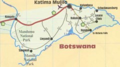
 Caprivi Map
The Caprivi map is a bit unusual to say the least. The Caprivi Strip is a 450km long protrusion, which extends the Namibian territory into an area that has as neighbors Zambia, Angola and Botswana. The rivers that are neighbors to this region are Zambezi, Chobe, Kwando and Okavango. The biggest town in the Caprivi Strip is called Katima Mulilo and it has a population of 28,000 people.
 The area is split between two regions, Okavango Region to the west and Caprivi Region to the east. The Caprivi area is home to 6 different ethnic tribes, something which is unique for the area, since no other region from Namibia has as many. The result is that a Zambian language ended up being the common way of communicating for the locals. Four different countries are neighbors to this region and they are all part of the SADC organization.
If you take a look at the Caprivi Strip map, you will notice that the capital, Katima Mulilo, can be found near Zambezi River. Quite a few villages exist in the area, so the area is well populated, but that’s the only major town you will see.
Thanks to the four major rivers in the area, both wetlands and riverine forests can be found on the Caprivi Strip. The wildlife is amazing as a result, with at least 600 bird species recorded, as well as four of the major 5 species (the rhino is the only one that’s not around). There are also a number of national parks in the area that take advantage of the wildlife. As for the geography, it’s simply amazing and definitely worth checking out if you’re anywhere near this area.
The Caprivi Strip owes its name to a German chancellor with the same name, that bought the area from the British.